The Yangtze River, also known as the “Chang Jiang“, is not only Asia’s longest river at 6,380 km but also the third-longest in the world, following the Amazon and the Nile. With an astonishing flow of 30,000 cubic meters of water every second, this mighty river originates in the Tanggula Mountains of Qinghai – a realm of glaciers, snowy terrains, and wind-swept moraines devoid of much vegetation.
Significance of the Yangtze River
As a cradle of civilization, the Yangtze River has been instrumental in shaping the cultural and historical landscape of China. For thousands of years, it has served as a vital artery for transportation, irrigation, and sanitation. The fertile lands along its banks are enriched by alluvial deposits, making them some of the most agriculturally productive areas in the country, where staples like rice and wheat are cultivated to feed millions.
Economically, the Yangtze facilitates a vibrant network of trade and commerce that supports the livelihoods of hundreds of millions of people. Additionally, the river plays a key role in China’s energy production. The construction of the Three Gorges Dam, the world’s largest power station by installed capacity – harnesses the Yangtze’s force, bolstering China’s renewable energy targets while helping manage historical flooding issues.
Flowing from the high peaks of the Tibetan Plateau to the bustling metropolis of Shanghai, the Yangtze traverses a sweeping tapestry of dramatic gorges, dense forests, and expansive plains. It connects rural communities to urban centers and weaves together traditional lifestyles and modern economies, truly making it a living, breathing emblem of China’s past and present.
Historical Importance of the Yangtze River
Ancient Civilizations and Cultural Growth
The Yangtze River basin has long been a pivotal region for the development of Chinese culture, economy, and politics. Ancient settlements flourished along its banks, largely due to the river’s life-giving waters that supported a rice-based agriculture. Besides providing irrigation, the river’s extensive network of tributaries allowed for efficient transportation and communication, which in turn spurred trade and the exchange of innovative ideas between regions.
Particularly, the Yangtze River Delta has historically been among the most densely populated and economically dynamic regions in China. Over centuries, the river also served as a formidable natural barrier that both protected and strategically influenced military campaigns, including pivotal battles such as those fought along its banks.
Historic Battles and Rebellions
The Yangtze has been a silent witness to many landmark events in Chinese history. For instance, the famous Battle of Red Cliffs in 208 AD helped lay the foundation for the Three Kingdoms era, demonstrating the strategic military importance of the river as both a line of defense and a logistical highway. In later centuries, conflicts like the Taiping Rebellion in the mid-19th century saw intense fighting along its banks, profoundly altering the socio-political landscape of the region.
Additionally, the Yangtze played significant roles during the Treaty of Nanjing in 1842, which concluded the First Opium War, and later during the Second Sino-Japanese War and the Chinese Civil War. In every era, whether in moments of turmoil or during periods of thriving cultural exchange, the river has remained an enduring emblem of China’s evolving narrative.
Route & Tributaries
The Yangtze River charts a vast and diverse course through China, flowing through the provinces of Qinghai, Yunnan, Sichuan, Hubei, Hunan, Jiangxi, Anhui, and Jiangsu. Along its path, the river also touches major urban centers such as Chongqing, Wuhan, Nanjing, and Shanghai.
Between Tibet and Sichuan
Initially known as “The Tuotuo River”, the Yangtze earns the name “Jinsha” (or “Golden Sands”) as it tumbles southward from its high-altitude origins. This section forms a natural boundary between Tibet and Sichuan, running parallel to other great rivers such as the Mekong. The first notable town it crosses is Qumar He, situated at 4,544 m above sea level. Here, the river also traverses the awe-inspiring Tiger Leaping Gorge, a canyon renowned for its dramatic depth of 2,000 m and breathtaking scenery.
Dongchuan City
As the river nears Dongchuan City, it takes a sharp northward turn, meandering through the rugged terrains of the Hengduan Shan Mountains in Yunnan. It then makes a sweeping eastward inflection, where major tributaries such as the Yalong, Min, and Jialing join its flow, ultimately diverting sediments away from the agriculturally rich Sichuan basin – home to over 120 million people and thriving farmland.
Chongqing City
Before merging with the Jialing River, the Yangtze courses past Chongqing, a vast metropolis of about 30 million inhabitants. Faced with frequent acid rain and industrial emissions, the city has earned a notorious reputation for environmental challenges. Nonetheless, Chongqing remains a crucial economic hub due to its strategic location along the river.
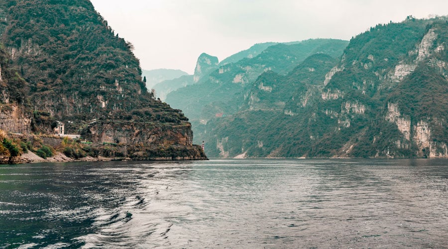
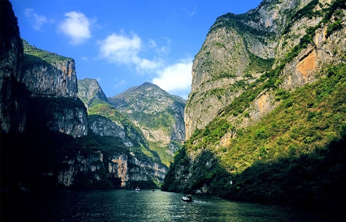
The Three Gorges
After the confluence with the Jialing, the river enters a sequence of three impressive gorges—collectively known as The Three Gorges. This area is famed for its mysterious atmosphere, where mist and water droplets shroud towering cliffs and rocky peaks. In summer, rising water levels during floods can increase by more than 100 meters, posing significant navigational hazards for the numerous boats plying the route between Chongqing and Yichang.
Poyang and Dongting Lakes
Beyond the gorges, the Yangtze slows and widens as it nears the coast, traversing several large lakes—most notably, Poyang and Dongting. These lakes are biodiversity hotspots home to sturgeons, spoonbills, and even endangered species such as the Chinese alligator, underscoring the region’s ecological importance.
Final Route and Delta
As the river approaches the East China Sea, it meanders through what is affectionately known as its “nine gut-shaped windings” before fanning out into an expansive delta. This fertile area, replete with farmlands, lakes, ponds, and reed beds, plays a critical role in supporting 40% of China’s land and nearly 70% of its rice production. Along its journey, the Yangtze collects water from more than 700 tributaries, draining a watershed of 1.8 million square kilometers and discharging nearly a trillion cubic meters of water into the sea each year.
Among the most significant of these tributaries is the Han River, which stretches for 1,532 km and merges with the Yangtze at Wuhan on its left bank. Other notable tributaries include:
- Gan River (758 km)
- Jialing River (1,119 km)
- Min River (735 km)
- Dadu River (1,155 km)
- Chishui River (523 km)
- Huai He (1,078 km)
- Wu Jiang (1,150 km)
- Yalong (1,323 km)
- Xiang River (856 km), joining Dongting Lake
- Yuan Jiang (864 km), also feeds into Dongting Lake
- You Shui (477 km)
- Huangpu (97 km)
- Suzhou (1,257 km)
Different Names of the Yangtze River
Yangzi Jiang
In Chinese usage, the name Yangzi Jiang traditionally refers to the downstream section of the river—from Nanjing to its mouth—deriving its name from the small town of Yangzi near Yangzhou. Europeans, however, later adopted this name to refer to the entire length of the river.
Shui
Historically, the river has also been called Jiang Shui or simply “Jiang.” In classical Chinese, “Shui” means water or river in a generic sense, while “Jiang” was once the proper name for what we now recognize as the Yangtze River. Over time, “Jiang” has evolved to broadly signify any large river.
Chang Jiang
Today, the entire river is universally known in Chinese as “Chang Jiang,” meaning “Long River.” Traditionally, however, each segment had its own distinct identity in literature and local lore, such as:
- Tuotuo: From the glaciers of Mount Geladaindong to the confluence with Dangqu in Qinghai.
- Tongtian He: Stretching from Qinghai to Yushu.
- Jinsha: In the upstream region of Yibin, this tributary of the Min River was historically considered the upper part of the Yangtze until the Ming Dynasty.
- Chuan Jiang: Running between Yibin and Yichang.
- Jing Jiang: Flowing between Yichang and Yueyang.
- Xunyang Jiang: Near Jiujiang in Jiangxi province.
- Wan Jiang: Located in Anhui Province.
- Yangzi Jiang: Downstream of Yangzhou and, by European convention, the entire river.
The Yangtze River as a Critical Agricultural Economic Zone
The vast Yangtze basin is not only ecologically rich – it is one of China’s most important agricultural zones. This region is responsible for 40% of the nation’s cereal yield and one-third of its cotton production. The Sichuan Basin is celebrated as “The Land of Plenty,” while the areas surrounding Dongting Lake and Poyang Lake are known as “the land where abundance reigns in fish and rice.” Additionally, the Tai Lake area is often described as resembling a paradise on earth due to its scenic beauty and productive lands.
Natural Fish Resources
The Yangtze River is a veritable warehouse for natural fish, supporting a vast array of freshwater species – a resource that accounts for nearly two-thirds of China’s total freshwater fish production. Despite the challenges posed by modern development, efforts to preserve these aquatic treasures continue.
Connection and Communication
Stretching across central China, the Yangtze forms an “H” shaped network linking the prosperous coastal areas with the more remote western regions. This natural channel not only serves as a crucial route for goods and cultural exchange but also fosters communication between disparate regions.
Trade and Industrial Linkages
By enabling the flow of resources from the resource-rich west to international markets via key trade centers such as Shanghai, Nanjing, Wuhan, and Chongqing, the Yangtze plays a pivotal role in powering China’s dynamic economy. Additionally, its waters transport industries and technological expertise, bridging the gap between traditional practices and modern advancements.
Aquatic Wildlife and Conservation
Historically home to unique species such as the baiji, or Yangtze Dolphin—which tragically became functionally extinct in 2007—the river is a reminder of the urgent need for conservation. Although some species have dramatically declined, there are ongoing efforts in selected sections of the river delta to protect and revive local aquatic populations, including the Chinese alligator.
Yangtze River Transport and Modern Improvements
China’s rapid economic growth has driven continuous improvements to the Yangtze River as a transportation corridor. In the 21st century, upgrades to navigation channels have boosted cargo capacity and efficiency. For example, in 2007, the total cargo load reached an impressive 1,123 billion tons – comparable to three times the capacity of Europe’s Rhine River.
Great Nanjing Bridge over the Yangtze
One of the most remarkable engineering feats along the river is the Great Nanjing Bridge. Completed in 1968, this two-tiered truss bridge spans the Yangtze between Pukou and Xiaguan in Nanjing. Its upper level accommodates the National Highway 104, while the lower deck carries the Beijing-Shanghai railway line – a testament to the river’s enduring role in connecting diverse regions of China.
Floods of the Yangtze River (1931)
The Yangtze River has long been both a giver of life and a force of nature, at times unleashing catastrophic floods. In August 1931, torrential rains combined with accelerated snowmelt, intensive tropical cyclones, and water-saturated lands to push the river beyond its limits. The resulting flood inundated vast regions, with some areas—such as around the Tung-Tin Lake—flooded to widths of 100-150 km. Even iconic locations like the Bund in Shanghai experienced submersion under 1.7 meters of water.
This disaster, which claimed nearly 3.7 million lives, remains one of the 20th century’s most devastating natural calamities (aside from those caused by pandemics and diseases). The unprecedented scale of the 1931 flood led to major developments in flood control and river management, including the construction of the Three Gorges Dam near the famed Three Gorges area. Today, this dam produces over 100 billion kWh of electricity annually, powering approximately 200 million people – a stark reminder of the intricate balance between harnessing nature’s bounty and mitigating its unpredictability.
Feel free to share your thoughts or additional insights in the comments below. Our professional guides are also available to answer any questions you may have about this remarkable waterway.
Do you have more information to add? Please leave your comments and thoughts for us. If you need further details, simply use the comment section, and our experts will get back to you as soon as possible.