

Traditional Calligraphy and Chinese Characters Class in Chengdu
Free Cancellation · Instant confirmation · Meet on location

Tashi Delek! Welcome to Lhasa, the capital of the Tibet Autonomous Region. Known in Tibetan as the "Holy Land" or "Land of the Buddha," it is a sacred city to the Tibetan people and a paradise for travelers. Thanks to the opening of the Qinghai-Tibet Railway, Lhasa is no longer out of reach. Bustling crowds and urban activity do not define the true essence of Lhasa; let us explore its mysterious charm together.
Upon your arrival at Lhasa Gonggar International Airport or Lhasa Railway Station, our tour guide will greet you with a *Khata* (ceremonial scarf) and warm wishes (please inform us of your mode of transport and arrival time in advance). You will then be escorted to your hotel in downtown Lhasa for check-in (note: the airport is located approximately 60 km southeast of the city center, a drive of 1 to 1.5 hours). After checking in, we recommend using the remainder of the day to rest and acclimate to Lhasa's high altitude. Allowing your body to adjust to the high-altitude environment is crucial before embarking on your exciting Tibetan journey.
【Friendly Reminders】
Regulations require foreign and Taiwan-resident tourists to be accompanied by a licensed tour guide upon arrival in or departure from Lhasa. The travel agency will provide instructions on hotel check-in procedures in advance; if you do not receive this information, please contact our staff immediately (details are in your tour confirmation letter). Your guide will contact you via phone or text message before 10:00 PM to confirm the meeting time for the following day.
【High-Altitude Sickness Precautions】
Get plenty of rest and maintain a calm state of mind—this is the best way to prevent altitude sickness.
Avoid strenuous exercise on the day of arrival and do not bathe or shower that evening to prevent catching a cold.
Refrain from drinking alcohol; instead, drink plenty of warm water, eat fruit, and avoid overeating.
If necessary, you may prepare herbal supplements or oxygen-support products—such as *Hongjingtian* (Rhodiola), American ginseng lozenges, or *Gaoyuan'an*—to help your body acclimate.
Please follow the advice of your tour guide and staff at all times; if you feel unwell, inform your guide immediately and seek medical attention.
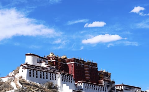
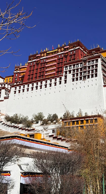
【Potala Palace】 (Maximum visit duration: 1 hour)
Songtsen Gampo spent half his life pacifying the Tibetan region and the other half constructing magnificent palaces and temples. Wandering through the resplendent prayer halls, stupas, private chambers, and corridors—amidst the soft glow of lights, draped curtains, and the pervasive scent of yak butter—one feels as though stepping into an ancient dream, captivated by the scriptures, Buddha statues, murals, and legends of old.
【Potala Palace Ticket Booking Information】:
Tickets for the Potala Palace require real-name reservation; valid identification (ID card, household registration booklet, Mainland Travel Permit for Taiwan Residents, or passport) is mandatory. Once a reservation is successful, a second reservation cannot be made within seven days of the scheduled visit. The travel agency bears no liability if entry is denied due to incorrect information provided by the tourist. Tourists must carry the original valid identification document for the visit; entry will be denied if the name or ID number does not match the document presented. Ticket costs are non-refundable once incurred; we appreciate your understanding.
Visit times are assigned via a centralized, randomized computer system managed by the Potala Palace administration; specific time slots cannot be requested. Please note that the actual tour route sequence may differ slightly from the itinerary.
Visitor numbers are restricted during peak season, and travel agencies in Tibet have limited daily group reservation quotas. To ensure a smooth visit, agencies utilize various booking channels; please follow the tour guide's instructions, as different channels may have specific requirements. The following scenarios are considered standard arrangements:
1) Groups may be split into smaller subgroups (this may involve separating members of the same group or party, and tourists might be combined with strangers for the visit).
2) Subgroups may visit at different times or on different dates.
3) Subgroups may be accompanied by different tour guides.
【Tibetan Cultural Experience】
While in Lhasa, you can also experience traditional Tibetan handicrafts (such as Tibetan incense making, woodblock printing, and learning about the Tibetan script). Visit the Tibetan Culture Experience Center to learn how the soothing Tibetan incense is crafted; you can even try making it yourself—an experience far more meaningful than simply buying it. A knowledgeable instructor will introduce the origins of the Tibetan script and help you write a blessing or your own name in Tibetan. You can also try your hand at traditional woodblock printing. The incense and prints you create, along with the Tibetan calligraphy written by the instructor, can all be taken home as souvenirs of your trip to Tibet.
【Barkhor Street】
This area was once the traditional circumambulation route (pilgrimage circuit) surrounding the temple. Today, Barkhor Street is a bustling hub filled with the scent of burning incense and the sounds of pilgrims chanting. You can savor butter tea in a teahouse, dress up in traditional Tibetan attire for photos, and browse for unique handicrafts and souvenirs from Tibet, Nepal, and India.
After setting off, the route follows the Yarlung Tsangpo River valley, offering bird's-eye views of the river. Along Provincial Highway 101, the Yarlung Tsangpo reaches its widest point near Lhasa; as you travel from the river valley onto Provincial Highway 307 and ascend the mountainside, the panoramic view of the river is vast and magnificent.
【Gangbala Mountain】 This offers the best vantage point to see Yamdrok Lake at its most beautiful—where the bluest skies meet the bluest waters. Here, you will truly understand the saying, "Tears of angels in heaven, the blue of Yamdrok on earth." Yet, many photographers remark, "No matter how many times you photograph Yamdrok Lake, you can never quite capture its full beauty..." Local Tibetans on the mountain offer yaks for photo opportunities; please agree on the price beforehand to avoid unnecessary issues.
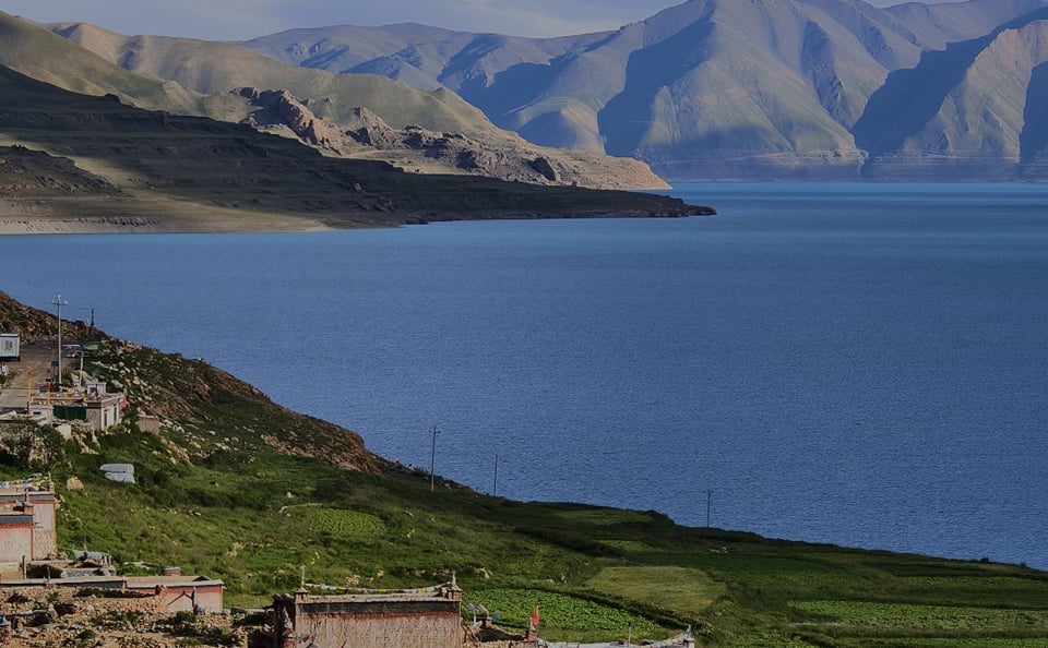
【Yamdrok Lake】 One of Tibet's three great sacred lakes, this freshwater lake boasts water as clear and pure as mutton-fat jade; it is sweet and safe to drink. The deep blue waters merge seamlessly with distant snow-capped peaks, complemented by colorful mountain ranges, distinctive Tibetan villages, and grazing herds of cattle and sheep along the way—a journey that is truly refreshing to the soul. Yamdrok Lake covers an area of 638 square kilometers, sits at an elevation of 4,441 meters, and has a shoreline stretching 250 kilometers. It is said to be a turquoise earring dropped into the mortal world by a goddess. Standing atop Gangbala Mountain at an altitude of 4,950 meters and looking south, Yamdrok Lake resembles a sapphire inlaid among the peaks; its azure waters are smooth as a mirror, reflecting the brilliant blue of the sky.
【Karola Glacier】
One of Tibet's three major continental glaciers, it is backed by Mt. Noijin Kangsang—one of Tibet's four great peaks. The massive glacier descends from the misty heights of the summit, extending down to within just a few hundred meters of the roadside. Although years of road dust have given the glacier a layered black-and-white appearance, its upper section—illuminated by sunlight—shines brilliantly, resembling a giant *thangka* painting hung against the mountainside. It has gained widespread renown as the location for the filming of movies such as *Red River Valley*, *The Battle of Gyantse*, and *The Knot*.
We will spend the night in Shigatse. The name "Shigatse" means "best manor" in Tibetan, and the region is known as one of "Tibet's granaries." Historically, it served as the political, religious, and cultural center of Tsang (Rear Tibet) and the seat of successive Panchen Lamas. With a history spanning over 500 years, it is currently the second-largest city in Tibet.
【Important Notes】
In addition to the Tibet Entry Permit, foreign nationals and visitors from Taiwan are required to register with the Shigatse Exit-Entry Administration Office. Tour guides may adjust the itinerary as necessary; please follow the guide's instructions and cooperate fully.
Departing from Shigatse—a major cultural hub of the Tsang region—the journey leads into the vast, secluded landscapes of the Western Tibetan Plateau. Along the way, the mountains shed their lush vegetation, revealing rock strata of intermingled ochre-red and blue-grey hues that stand out with rugged, weathered textures under the sunlight.
Upon reaching the Sangsang Grassland, a sea of green suddenly unfolds before your eyes. In the height of summer, the meadows are carpeted with purple *Pedicularis* (lousewort) and yellow *Gesang* flowers. Herds of yaks and Tibetan sheep dot the landscape like stars scattered across a green velvet rug, while the black tents of herders—with wisps of cooking smoke rising gently—punctuate the scenery. Majestic eagles occasionally circle overhead, and the breeze carries the mingled scent of fresh grass and yak butter, fully capturing the vibrant, expansive spirit of the highland steppe.
Continuing west toward Saga, the landscape gradually shifts into a semi-desert terrain. The road winds between river valleys and mountain ranges; snow-capped peaks loom in the distance, while clusters of sparse sea buckthorn and red willow dot the foreground. At sunset, the fading light gilds the mountain ridges, and the boundary between grassland and desert blurs in the twilight, evoking the unique, vast, and majestic atmosphere of Western Tibet.
【Travel Tips】
Accommodation options for foreign travelers at the destination are limited; your overnight stay may be arranged in either Saga or Zhongba.
Setting out from Saga or Zhongba, the vehicle travels along the highway skirting the northern foothills of the Himalayas as the elevation gradually rises. Tibetan-style villages in Zhongba dot the edge of the wilderness like prayer flags. The multicolored desert landscape shimmers in the sunlight, resembling an overturned palette of mineral pigments. Passing Gongzhu Co, one is captivated by the sight of the Gangdise Mountains reflected in the lake's jewel-blue waters.
When the sacred Lake Manasarovar suddenly comes into view, words fail to do it justice. This "ever-victorious turquoise lake" is a holy site revered by followers of Bon, Buddhism, and Hinduism alike. Tibetan pilgrims circumambulate the lake, prayer wheels in hand, having etched their faith into every single Mani stone. Finally, the journey concludes at Darchen.
(Approx. 20 km: 6 km by vehicle + 14 km on foot)
Start Point: Darchen (Elevation: 4,675m)
End Point: Drirapuk Monastery / Gangjia (Elevation: 5,100m)
Distance: Approx. 20 km total (includes a ~6 km eco-bus ride to the Prayer Flag Square/Tarboche and a ~14 km hike)
Hiking Duration: Approx. 7–8 hours
Difficulty Level: **
In the early morning, board the eco-bus from Darchen to the Prayer Flag Square to begin the kora (pilgrimage circuit). The scenic area offers rental services for yaks and porters for those with heavy luggage, as well as horse rentals for those who may find the physical exertion challenging. Adjust your breathing, find your rhythm, and traverse this sacred land on foot.
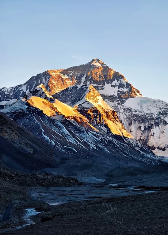
As you ascend the valley accompanied by blue skies and snow-capped peaks—with the occasional river winding alongside—you will experience the awe-inspiring craftsmanship of nature firsthand. Along the way, you will view the western and northern faces of Mount Kailash: one side towering into the clouds, the other revealing endless, undulating layers of rock. This journey offers a unique encounter with the mountain, providing diverse perspectives and a profound experience. After completing the 14-kilometer trek, you will arrive at Drirapuk Monastery. Amidst the fluttering colorful prayer flags, you will rest and sleep, filled with devotion to your faith and reverence for nature.
[Friendly Reminders]
The tour fee does not include the cost of horse riding, or hiring yaks, yak handlers, or porters; if needed, visitors must arrange and pay for these services independently.
The pilgrimage attracts large crowds during the "Year of the Horse"; if you require these services, please inform your tour guide in advance to arrange a booking.
Accommodation and dining conditions during the hike are basic; for the two nights of the pilgrimage, accommodation is arranged in local guesthouses (shared dormitory rooms with public restrooms; one bunk per person).
(Hike of approx. 20 km)
(Drirapuk/Gangja → Dolma La Pass → Zutulpuk)
Start: Zhire Monastery / Gangjia (Altitude: 5,100m)
Pass to Cross: Dolma La (Altitude: 5,650m)
End: Zuthul Puk Monastery (Altitude: 4,880m)
Distance: Approx. 20km hike
Duration: 10–11 hours
Difficulty: ***
After a good night's rest to fully replenish your energy, you will begin the day's trek. Today, you will cross the highest point of the pilgrimage: the Dolma La Pass (5,650m). At the pass, colorful prayer flags flutter in the breeze, and below in the valley lies a beautiful small alpine lake—the "Lake of Compassion"—resembling a piece of translucent white jade inlaid amidst the towering peaks. The descent begins after crossing Dolma La, making the physical exertion much less demanding. You will spend the night at a guesthouse near Zuthul Puk Monastery.
Along the way, you will encounter many devout Tibetans prostrating themselves in prayer. Loose stones tumble down the valley with a rattling sound, making the walk somewhat challenging; indeed, this pilgrimage path is a route to holiness carved out by the bodies and footsteps of Tibetans navigating ice, snow, and scree over the passage of time. While the journey along this sacred path is arduous, you can take a break at a local teahouse along the way to rest and regain your strength.
(Zuthul-puk Monastery → Zongdui → Darchen; transfer to our own tour vehicle for the journey to Zanda)
Starting Point: Zuchu Monastery (Elevation: 4,880m)
Hiking Endpoint: Zongdui (Elevation: 4,680m)
Final Destination: Darchen (Elevation: 4,675m)
Distance: 10.6 km (approx. 6.6 km on foot + 4 km by eco-bus)
Hiking Duration: 2–3 hours
Difficulty: *
On the third day of the kora (pilgrimage circuit), as the altitude drops, the landscape shifts from snowy white to lush green. Small animals become active among the shrubs, and the atmosphere teems with a growing sense of vitality. Beyond the wildlife, colorful piles of mani stones—stacked amidst the snowy peaks and grasslands—stand like monks deep in prayer. Upon completing the final 6.6-kilometer hike around midday, those feeling exhausted and hungry can take the eco-bus back to Darchen. After a lunch break, the journey continues to Zanda.
Set out from the town of Zada for a journey that offers a magnificent feast of both culture and landscapes in Western Tibet. First, visit the **Ruins of the Guge Kingdom**, where sunlight slants across red walls and broken columns; these ancient, crumbling structures silently recount the rise and fall of the Tibetan descendants, and a closer look reveals faint traces of surviving murals. Next, step into the **Zada Earth Forest**, where earthen mounds stretch for miles like a gallery of natural sculptures; the interplay of light and shadow across the ravines creates a majestic spectacle that leaves one speechless.
Continue to the **Xiayigou Earth Forest**, where rock strata—interwoven with shades of pale red and earthy yellow—vividly stand out against the blue sky; it is a hidden gem that yields stunning, high-quality photos with every casual snapshot. Finally, arrive at **Shiquanhe**; here, prayer flags flutter gently by the roadside, and a hot drink washes away your fatigue, allowing you to savor the unique tranquility and warmth of this highland supply town in Ngari.
Embark on a high-altitude road trip from Shiquanhe to Gaize, immersing yourself in the scenery of Northern Tibet’s salt lakes and vast wilderness. First, make a brief stop in Geji County to experience the tranquility of this small town in Northern Tibet. Next, arrive at Nie'er Cuo, where the lake surface glimmers with the silvery light of salt crystals and gentle ripples dance in the breeze—a scene of pristine, natural clarity. Upon reaching Yanhu Township, catch glimpses of herders' felt tents and free-roaming livestock, feeling the authentic pulse of Tibetan life. Ascend the observation deck at Bieruoze Cuo to gaze down at the lake’s shifting blue-green gradients—a magnificent sight that creates a striking contrast with the surrounding earthy-yellow landscape and compels you to pause and admire the view. Finally, pass by Wuma Cuo and watch waterbirds skim across the surface before arriving in the county seat of Gaize, where you can shake off the fatigue of the journey in the comfort of your accommodation.
Setting out from Gerze, you enter the vast, picturesque landscape of the Qiangtang region in northern Tibet. Along the way, boundless grasslands stretch out, dotted with grazing herds of yaks and sheep, while snow-capped peaks in the distance span the horizon like a silver ribbon. Upon reaching Dongcuo, you encounter a brilliant blue lake set amidst the wilderness; waterfowl occasionally dart through the wetland vegetation, adding a touch of lively motion to the expansive, rugged landscape.
Continuing the journey, the blue waters of Dangre Yongcuo gradually unfold before you, shifting in hue between deep and pale shades as the light changes. The peaks of the Daguo Snow Mountain range are mirrored in the lake, creating a scene of majestic sanctity. Finally, you arrive at Wenbu South Village; nestled between the mountains and the lakeshore, the village features earthen-hued dwellings that contrast beautifully with the azure water and reddish-brown mountains. Ancient prayer flags flutter in the wind, perfectly blending the untamed spirit of northern Tibet with its rich cultural heritage.
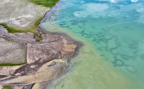
Setting out from the secluded village of Wenbu South—tucked away in northern Tibet—one is greeted by the azure waters of nearby Dangqiong Co, where the reflections of drifting clouds mingle with herds of livestock strolling leisurely along the shore. Traditional Tibetan dwellings stand amidst fluttering prayer flags, creating a scene rich in authentic highland charm. Next, the journey leads to the "Tree of the Sky," where naturally formed patterns on the salt flats resemble a colossal tree rooted in the earth—a sight that is truly breathtaking when viewed from the air.
The route continues to Seling Co, Tibet’s second-largest lake; its vast, sea-like expanse shimmers as waterfowl skim the waves, while Tibetan gazelles pause along the banks, embodying the vibrant life of the plateau. Passing by Banggo Co, one witnesses the tranquil waters shifting through hues of pale blue and light green as the light changes, painting a picturesque scene against the surrounding grasslands. Finally, the journey concludes in the town of Banggo, where the comforts of a warm lodge offer a chance to shake off travel fatigue and cherish the memories of the stunning lakeside scenery.
Setting out from Bango, the vast, sweeping panorama of the Northern Tibetan grasslands gradually unfolds. Expansive meadows stretch toward the horizon, dotted with black-and-white herds of yaks and sheep; occasionally, a majestic eagle swoops low, embodying the rugged grandeur of the plateau. Upon entering the Namtso National Scenic Area, one finds the Zhaxi Peninsula nestled against the sacred azure lake. The waters mirror the graceful silhouette of the snow-capped Nyainqêntanglha Mountains, prayer flags flutter briskly in the wind along the cliffs, and traditional Tibetan dwellings dot the landscape, creating a harmonious blend of culture and nature.
【Namtso Scenic Area】
As one of Tibet’s three great sacred lakes, Namtso is renowned worldwide for its breathtaking natural scenery and profound cultural heritage. Situated at an altitude of 4,718 meters, the lake displays varying shades of blue that shift with the light and weather. The Zhaxi Peninsula—a limestone formation that serves as the heart of the scenic area—features unique karst landforms: forests of stone pillars and natural stone arches appear and disappear amidst the waters; the "Welcoming Rock" (also known as the "Couple Rock") greets pilgrims with outstretched "arms"; and the natural stupa-like formation within the Padmasambhava Cave adds an air of mystery. Wisps of incense smoke rise from the Zhaxi Monastery on the peninsula, and colorful prayer flags line the circumambulation path; together with the ochre-red mountains and the deep blue lake, they form a living *thangka* painting.
Reaching the Nagenla Pass, one stands at an altitude of 5,190 meters to gaze out at the panoramic view of Namtso, where the lake and sky merge into an endless expanse of majesty. Descending and traveling southward, the landscape softens; stretches of farmland and villages appear in the river valleys as the journey concludes in Lhasa.
After breakfast, you will be transferred to the airport or train station according to your departure schedule, marking the end of your pleasant journey. As the drive from the city center to the airport takes approximately one hour, we recommend scheduling flights departing after 10:00 AM.
【Important Reminders】
Regulations require that foreign nationals and visitors from Taiwan be accompanied by a licensed tour guide upon arrival in or departure from Lhasa.
Your tour guide will verify your departure details in advance; please ensure you provide an accurate flight itinerary or train ticket booking confirmation so the travel agency can efficiently coordinate the complimentary group transfer service.
Fully refundable until 1 day before start
Non-refundable after 1 day before start
Free Cancellation · Instant confirmation · Meet on location
Free Cancellation · Instant confirmation · Private tour
Free Cancellation · Instant confirmation · Private tour
Free Cancellation · Instant confirmation · Private tour

Free Cancellation · Instant confirmation · Private tour
Free Cancellation · Instant confirmation · Pickup available
Free Cancellation · Instant confirmation · Pickup available
Free Cancellation · Instant confirmation · Pickup available
Our assistant finds tours and checks live dates and prices, and answers your questions.