
Himalayan Adventure Tour: Explore Amritsar, Dalhousie, Dharamsala
Free Cancellation · Instant confirmation · Private tour
Arrival at Islamabad International Airport. A Pak Tours & Travels team member will be ready to welcome you and escort you to your hotel. Get some rest and freshen up, ready for a welcome meal and a briefing of your journey ahead.
Night stay in Islamabad
Overnight Stay in 3 star Hotel in Islamabad
This Guided Day Trip will introduce you to one of the oldest Civilization on earth the Gandahara Civiliation, Ancient Buddhist civilization, a vibrant community dated back 2500 years ago. The oldest univercities and learning centers in the world. Owing to its strategic location, many empires fought for its control over the time. In 1980, Taxila was declared a UNESCO World Heritage Site. In 2006 it was ranked as the top tourist destination in Pakistan by The Guardian newspaper. You will explore Taxila Museum, Taxila Ruins, Jaulian Buddhist Monastery, Dharmarajika Stupa And Monastery and some other attractions. An English guide will accompany you during the tour. Hotel pick up and drop off from Islamabad.
Read more about Full Day Private Guided Tour of Taxila Gandahara Civilization -
axila Museum is located at Taxila, Punjab, Pakistan. The museum is home to a significant and comprehensive collection of Gandharan art dating from the 1st to the 7th centuries CE. Most objects in the collection were excavated from the ruins of ancient Taxila. There are many historical sites nearby the museum
Besham Continental or similar Hotel
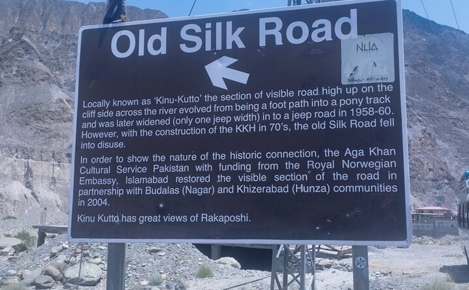
The Karakoram Highway (KKH), also known as the China-Pakistan Friendship Highway, is a 1,300 km (800 mile) road that connects the cities of Kashgar, China, and Hasan Abdal, Pakistan, traversing the Karakoram mountain range. It's a remarkable feat of engineering, known for its scenic beauty and challenging terrain, and is often called the "Eighth Wonder of the World".
Construction began in 1959 and was completed in 1979, with the highway opening to the public in 1986. It involved the cooperation of Pakistan and China.
Significance:
The KKH is an important artery for trade and transportation between China and Pakistan, and it's also a popular tourist destination.
The KKH offers breathtaking scenery, including glaciers, high peaks, ancient rock carvings, and historic forts.
Attractions:
Some popular destinations along the KKH include Fairy Meadows, Hunza Valley, and Gilgit.
Chilas is a city in Pakistani-administered Gilgit–Baltistan in the disputed Kashmir region. It is the divisional capital of Diamer Division and is located on the Indus River. It is part of the Silk Road, connected by the Karakoram Highway and N-90 National Highway to Islamabad and Peshawar in the southwest, via Hazara and Malakand divisions of Khyber Pakhtunkhwa. To the north, Chilas connects to the cities of Tashkurgan and Kashgar in Xinjiang, China, via Gilgit, Aliabad, Sust, and the Khunjerab Pass.
Chilas is the headquarters of Diamer district. The weather is hot and dry in the summer and cold and dry in the winter. It can be reached by the Karakoram Highway and also through the Kaghan valley via the Babusar Pass. Chilas is on the left bank of the Indus River. The beautiful Fairy Meadows National Park and Nanga Parbat, the ninth highest peak in the world, are also located in Chilas.
Karakoram International University has a sub-campus in Chilas
Nanga Parbat ( 'naked mountain'), known locally as Diamer (Shina: 'King of the Mountains'), is the ninth-highest mountain on Earth and its summit is at 8,126 m (26,660 ft) above sea level. Lying immediately southeast of the northernmost bend of the Indus River in the Gilgit-Baltistan region of Pakistan-administered Kashmir, Nanga Parbat is the westernmost major peak of the Himalayas, and thus in the traditional view of the Himalayas as bounded by the Indus and Yarlung Tsangpo/Brahmaputra rivers, it is the western anchor of the entire mountain range.
Nanga Parbat is one of the 14 eight-thousanders. An immense, dramatic peak rising far above its surrounding terrain, it has the second-highest prominence among the 100 tallest mountains on Earth only behind Mount Everest. Nanga Parbat is notorious for being an extremely difficult climb, and has earned the nickname Killer Mountain for its high number of climber fatalities and pushing climbers to their limits.
Kallisto Hotel or similar
Rakaposhi (Burushaski: 'Shining Wall') also known as Dumani (Burushaski: 'Mother of Mist') is a mountain within the Karakoram range in Gilgit-Baltistan in Pakistan. It is situated in the middle of the Nagar and Bagrote valleys. The mountain is extremely broad, measuring almost 20 kilometres (12 mi) from east to west. It is the only peak on earth that descends directly and without interruption for almost 6,000 meters from its summit to its base
Hunza was a Burusho princely state in the present-day Gilgit Baltistan region of Pakistan. it functioned as a principality and subsequently became a princely state under a subsidiary alliance with the British India starting in 1892 and continuing until August 1947. For a brief period of three months, it remained unaligned after gaining independence, and then from November 1947 until 1974, it retained its status as a princely state within Pakistan. The territory of Hunza now constitutes the northernmost part of Gilgit-Baltistan, Pakistan.
The princely state bordered the Gilgit Agency to the south, the former princely state of Nagar to the east, Xinjiang, China, to the northeast and Afghanistan to the northwest. The state's capital was Baltit (also known as Karimabad). The princely state of Hunza is now the Hunza District in the Gilgit Baltistan region of Pakistan.
Hilltop Hotel Karimabad Hunza or Similar
Karimabad town is situated on the western bank of the Hunza River, opposite Nagar Valley nestled in the lower Hunza Valley. It lies at an elevation of 8,200 feet (2,500 meters) above sea level. Historically, Karimabad served as a caravan stop for travelers journeying through the Hindu Kush mountains en route to Kashmir.
The town is framed by deep gorges and is set against the backdrop of snow-clad mountain peaks like Rakaposhi, which stands at an altitude of approximately 25,000 feet (7,600 meters), Diran, Golden Peak and Ultar Peak. All four peaks have dedicated view points in and around the town. Access to Karimabad is primarily via a hill road leading from Aliabad.
Altit lies to the lower west of Karimabad at a mere distance of 3 km. To the direct south of town, lies the ancient settlement of Ganish. Aliabad is around 7 km to the west. Duikar is to the north-west from the town. In the far east is Attabad Lake. The confluence of the Hunza River and Nagar River lies in Ganish.
Altit Fort is an ancient fort in the Altit town in the Hunza valley in Gilgit Baltistan, Pakistan. It was originally home to the hereditary rulers of the Hunza state who carried the title of 'Mir', although they moved to the somewhat younger Baltit fort nearby three centuries later.Altit Fort and in particular the Shikari tower is around 1100 years old, which makes it the oldest monument in the Gilgit–Baltistan. The fort has received the UNESCO Asia Pacific Heritage Award for Cultural Heritage Conservation in 2011
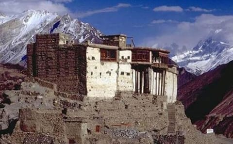
Baltit Fort is a fort in the Hunza valley, near the town of Karimabad, in the Gilgit-Baltistan region of northern Pakistan. Founded in the 8th century CE, it has been on the UNESCO World Heritage Tentative list since 2004.
The Mirs of Hunza abandoned the fort in 1945, and moved to a new palace down the hill. The fort started to decay which caused concern that it might possibly fall into ruin. Following a survey by the Royal Geographical Society of London a restoration programme was initiated and supported by the Aga Khan Trust for Culture Historic Cities Support Programme. The programme was completed in 1996 and the fort is now a museum run by the Baltit Heritage Trust.
Hilltop Hotel Karimabad Hunza
Attabad Lake also known as Hunza Lake, is a lake located in the Gojal region of Gilgit-Baltistan, a region within the disputed territory of Jammu and Kashmir administered by Pakistan. It was formed in January 2010 when a significant landslide impounded the water in the Hunza River in Attabad village. The lake offers a diverse range of activities, from boating, jet-skiing, and fishing to various winter sports, attracting attention year-round
Ganish also Ganesh or Ganish Khun is a village in the Hunza District within the Gilgit Baltistan region of Pakistan. Ganish also collectively refers to multiple villages in and around the area. It is the oldest and first settlement on the ancient Silk Road in the Hunza Valley, and is the site of various ancient watchtowers, traditional mosques, religious centers, and a reservoir. The settlement is at least a 1,000 years old and was awarded the UNESCO Asia-Pacific Heritage Award for Culture Heritage Conservation in 2003.
Gulmit, also known as Gul-e-Gulmit , in upper Hunza Gilgit Baltistan, Pakistan. Gulmit is a centuries-old historic town, with mountains, peaks and glaciers. It is a tourist spot and has many historic places, hotels, and shops as well as a museum.
Passu Glacier is situated in the south side of Passu village, in Karakoram Range in Gilgit-Baltistan, Pakistan. Passu Peak is situated behind the glacier. This glacier is linked with Batura Glacier and many other glaciers in Batura Muztagh mountain range.
During the British colonial era, several explorers and surveyors documented their journeys through the Karakoram region, including observations of the Passu Glacier. These accounts provide valuable historical insights into the glacier's condition and the surrounding area's geography during that period.
Sarai Silk Route Passu or similar
Khunjerab National Park is a national park in Gilgit Baltistan, Pakistan. Khunjerab National Park is Pakistan's third largest national park, and is adjacent to the Taxkorgan Natural Reserve in China.
Khunjerab Pass is a mountain pass in northern Pakistan that lies at an elevation of 4,693 metres (15,397 ft) above sea level. It is located in the Karakoram and holds a significant strategic position on the northern border of Pakistan, specifically in the Gilgit-Baltistan's Hunza and Nagar Districts. Additionally, it is positioned on the southwestern border of China, within the Xinjiang region.
Near Khunjerab Pass, there is another pass known as Mutsjliga Pass , which stands at an elevation of 5,314 metres (17,434 ft) and is located at approximately 36.97374°N 75.2973°E.
Sarai Silk Route Passu or similar
Hussaini Suspension Bridge is a pedestrian hanging bridge over the Hunza River in Gilgit Baltistan's Karakoram range. It was originally built for local access but has become a popular tourist attraction due to its striking structure and dramatic location.
Passu Glacier is situated in the south side of Passu village, in Karakoram Range in Gilgit-Baltistan, Pakistan. Passu Peak is situated behind the glacier. This glacier is linked with Batura Glacier and many other glaciers in Batura Muztagh mountain range.Passu Glacier is situated in the south side of Passu village, in Karakoram Range in Gilgit-Baltistan, Pakistan. Passu Peak is situated behind the glacier. This glacier is linked with Batura Glacier and many other glaciers in Batura Muztagh mountain range.
Sarai Silk Route Hotel Passu or similar
The Kaghan Valley is an alpine valley in Mansehra District of Khyber Pakhtunkhwa, Pakistan. The valley stretches 155 kilometres (96 mi) across the northern Pakistan, rising from its lowest elevation of 650 m (2,134 ft) to its highest point at the Babusar Pass around 4,170 m (13,690 ft).[1] Furthermore, the highest mountain peak in the valley known as Malika Parbat (lit. 'Queen of Mountains'), stands with a height of around 5,290 metres (17,360 ft). Landslides triggered by the devastating 2005 Kashmir earthquake destroyed many passes leading into the valley, though roads have since been rebuilt. Kaghan is a popular tourist attraction in Pakistan.
Shangrila Hotel in Chilas or northern Retreat Hotel in Naran
Naran is the most beautiful place in Kaghan Valley. snow coverd Peaks, beautiful lakes and very scenic and cold atmosphere in sorroundings.
Hotel Hillview or Similar in Islamabad
Departure
Departure for Islamabad International Airport as per scheduled flight for onward destination.
Fully refundable until 1 day before start
Non-refundable after 1 day before start
Free Cancellation · Instant confirmation · Private tour

Free Cancellation · Instant confirmation · Private tour

Free Cancellation · Instant confirmation · Private tour

Free Cancellation · Instant confirmation · Private tour

